ALABAMA — The warmest weather of 2026 is arriving across Alabama and the Deep South this week and it is not going to be subtle. Afternoon highs are expected to surge well into the 80s today and continue climbing through the week, with some locations across the region touching a dangerous 90 degrees during the latter half of the week. This is not just a warm stretch. This is a heat event that will stress crops, intensify drought conditions, and push residents to their limits during what should still be a mild spring season.
Temperatures Surging Into the 80s and Touching 90 Degrees
The temperature forecast for Alabama and the broader Deep South region this week is alarming. Afternoon highs are projected to reach the mid to upper 80s on most days, with peak temperatures approaching 89 and 90 degrees forecast toward the end of the week. Morning lows will remain in the low to mid 60s, providing only limited overnight relief before the heat builds again each afternoon.
This level of warmth in mid April is well above normal for the region and represents the highest temperatures recorded anywhere in the Deep South so far in 2026. Residents with outdoor jobs, elderly individuals, and those without air conditioning need to take this heat seriously and take precautions starting today.
Upper Ridge Blocking All Rain for the Next 6 to 7 Days
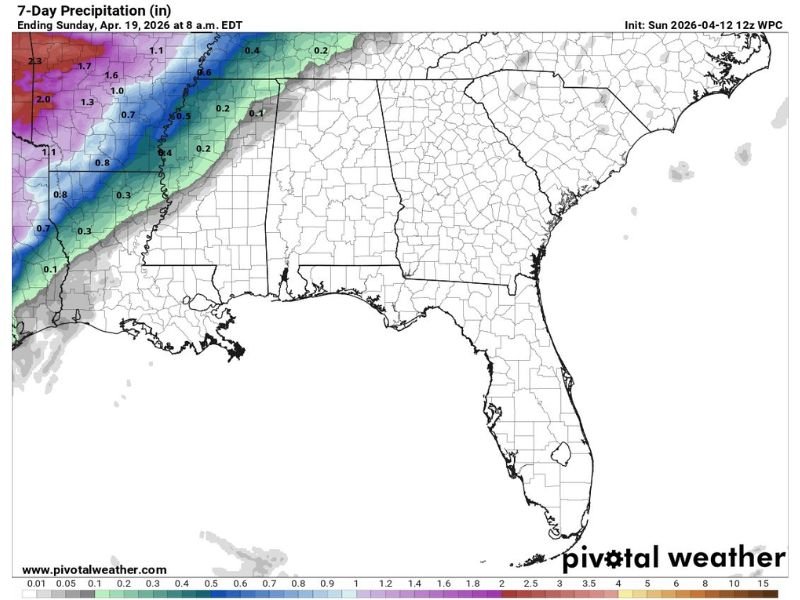
The powerful upper level ridge responsible for driving this extreme warmth is doing something equally dangerous at the same time. It is acting as a wall that is pushing all rain and storm activity well to the west and north of Alabama for at least the next six to seven days. That means no meaningful rainfall relief is coming anytime soon for a region that is already watching drought conditions intensify.
Drought stress on vegetation, crops, and water supplies will worsen significantly through the week as heat and dry conditions combine without any precipitation to offset the impact.
Pattern Shift Possible in 10 to 15 Days But Not Soon Enough
There is a small silver lining on the distant horizon. Forecasters are beginning to see evidence of a pattern shift developing in the 10 to 15 day range that could eventually bring some much needed rain and thunderstorms back to Alabama and the Deep South. However, that potential relief is still nearly two weeks away at the earliest and is far from guaranteed.
In the meantime, residents are urged to stay hydrated, limit outdoor exposure during peak afternoon heat hours, and monitor local drought updates closely as conditions continue to deteriorate across the region this week.
Leave a Reply