If you live anywhere from Kansas to Texas, today is not the day to leave your car outside. The Storm Prediction Center’s Day 1 outlook, updated April 26, 2026 at 10:01 AM ET, shows a significant hail threat stretching across a massive swath of the central United States — and forecasters are warning that hail the size of a hen’s egg, or even a tennis ball, is possible.
Who Is Most at Risk?
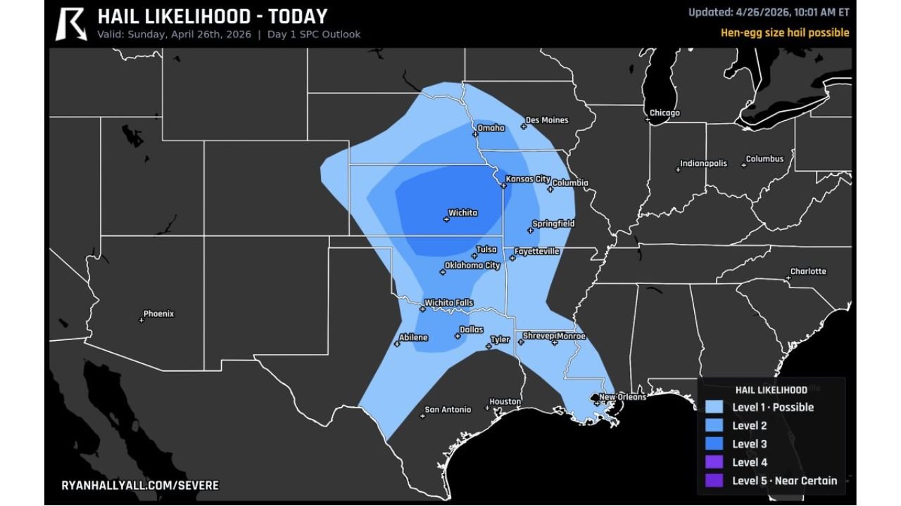
The hail likelihood map, sourced from RyanHallYall.com/severe, paints a clear picture of where the danger is highest today:
- Wichita, KS — sitting near the core of the highest-risk zone
- Oklahoma City and Tulsa, OK — both under elevated hail threat
- Kansas City, MO — on the northern edge of the risk area
- Dallas and Tyler, TX — southern corridor also in the danger zone
- Springfield, MO and Fayetteville, AR — included in the Level 2–3 hail risk
The darkest blue zones on the map — Level 3 and above — indicate areas where large, damaging hail is not just possible but increasingly likely as storm cells fire up during the afternoon hours.
How Big Are We Talking?
Forecasters have specifically flagged hen-egg size hail as possible across the most at-risk areas. To put that in perspective:
- Golf ball size — 1.75 inches in diameter
- Hen egg size — approximately 2 inches in diameter
- Tennis ball size — 2.5 inches in diameter
Hail of this magnitude can shatter car windshields, damage roofs, destroy crops, and pose a serious risk of injury to anyone caught outdoors without shelter.
What Should You Do Right Now?
- Move vehicles into a garage or covered parking immediately
- Avoid unnecessary travel this afternoon and evening if you are in the risk zone
- Stay indoors when storms approach — do not go outside to watch
- Keep a NOAA Weather Radio or weather app with alerts turned on
- If you have outdoor furniture, plants, or fragile equipment — bring them inside now
This Is Not a Drill
The central U.S. has already had an active severe weather season in 2026, and today’s setup is the kind that meteorologists take seriously. A strong upper-level system combined with ample moisture flowing in from the Gulf is creating the atmospheric ingredients needed for supercell thunderstorms — the type most efficient at producing large hail and tornadoes.
Even areas on the outer edges of the Level 1 zone, stretching from Omaha down through San Antonio, should remain alert throughout the day. Storms can and do produce hazardous hail even outside the highest-risk zones.
Leave a Reply