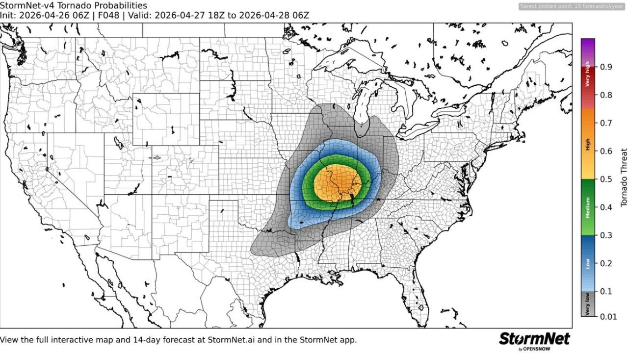
A new forecast from StormNet-v4, initialized Saturday night and valid from 18Z April 27 through 06Z April 28, 2026, is showing an elevated and concentrated tornado threat centered over the central United States. The model’s tornado probability map leaves little room for optimism for residents in the heart of the country — the bullseye is clear, and it is serious.
What the Probability Map Is Showing
The StormNet-v4 tornado probability forecast breaks the threat down into distinct zones, each representing the likelihood of a tornado occurring within a given area during the valid period:
- Very Low (0.01–0.1): Broad outer zone covering much of the central and eastern U.S. — a baseline risk that should not be ignored
- Low (0.2–0.3): A tightening ring indicating a meaningful tornado threat across parts of the Midwest
- Medium (0.4): Elevated concern — residents in this zone should be actively monitoring conditions
- High (0.6–0.7): Significant tornado probability, covering the core of the risk area across the central plains and lower Midwest
- Very High (0.8–0.9): The innermost zone, colored orange to yellow on the map, representing the area with the greatest tornado likelihood Monday evening
Where Is the Highest Risk Centered?
The yellow and orange core of the probability map — representing tornado probabilities of 0.5 and above — sits squarely over the central plains and lower Midwest. Based on the map’s geography, the highest-risk area aligns with portions of Illinois, Missouri, Indiana, and neighboring states, consistent with other severe weather outlooks issued for Monday’s event.
The broader grey shading extends the low-level risk across a vast area stretching from the Rockies to the East Coast, a reminder that even areas outside the core can experience isolated tornado activity when large-scale outbreak setups are in place.
Why This Forecast Matters
StormNet-v4, developed by OpenSnow, uses advanced machine learning techniques to generate tornado probability forecasts at a county-by-county level. The model was initialized on Saturday night, giving forecasters a 48-hour look ahead at Monday’s tornado potential. The fact that probabilities are this elevated two days out underscores just how well-organized and threatening this storm system is expected to be.
When multiple independent forecast models and meteorological organizations are all pointing to the same region with the same level of concern, the message is consistent: Monday evening is not a night to be caught off guard.
How to Prepare Before Monday Arrives
- Know your shelter location now — do not wait until warnings are issued
- Have multiple ways to receive tornado warnings: phone alerts, NOAA Weather Radio, and local TV
- If you are in a mobile home or vehicle, identify a nearby sturdy structure ahead of time
- Keep a go-bag ready with essentials: water, medications, documents, flashlight, and phone charger
- Check in with family members and neighbors, especially those who may need extra help
- Stay off the roads Monday evening — tornadoes and driving do not mix
The time to prepare is now, not when the sirens go off. Monday’s setup has the ingredients for a significant and dangerous tornado outbreak across the central U.S.
For more severe weather news and analysis, visit readcultured.com — your source for news that matters.
Published for informational purposes only. Forecast data is subject to change as the event approaches. Always follow official guidance from the National Weather Service and local emergency management authorities.
Leave a Reply