A significant and potentially historic tornado threat is taking shape for Monday, April 27, 2026, across a large portion of the central United States. The latest tornado intensity outlook is not just forecasting tornadoes — it is forecasting violent tornadoes, with EF3 and higher intensity possible across a wide and heavily populated area.
What the Tornado Intensity Forecast Is Showing
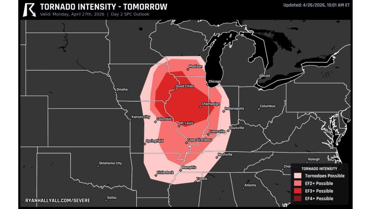
The outlook, valid for Monday April 27, breaks the tornado threat into four intensity zones — and the highest categories cover some of the most populated cities in the Midwest:
- Tornadoes Possible (Light Pink): A broad outer zone stretching from Omaha and Kansas City down through Little Rock, Memphis, and Tupelo — a wide area where any storm could produce a tornado
- EF2+ Possible (Pink): Covering Chicago, Madison, Indianapolis, Louisville, Nashville, and Springfield — significant tornadoes capable of causing major damage to well-built homes
- EF3+ Possible (Red): The most expansive high-end zone, centered over St. Louis, Champaign, Quad Cities, Columbia, Cape Girardeau, and Evansville — violent tornadoes capable of destroying well-constructed structures
- EF4+ Possible (Dark Red): The innermost and most dangerous zone, covering portions of central Illinois and Missouri — catastrophic, potentially deadly tornadoes that can level entire neighborhoods
Cities Directly in the Crosshairs
The sheer size of the EF3+ and EF4+ zones is what makes Monday’s threat so alarming. Major metropolitan areas sit inside these highest-risk zones:
- St. Louis, MO — inside the EF3+ zone, one of the largest cities directly threatened
- Champaign and Quad Cities, IL — within the EF4+ possible corridor
- Columbia and Cape Girardeau, MO — elevated violent tornado risk
- Evansville, IN — on the eastern edge of the EF3+ zone
- Chicago, IL — inside the EF2+ zone, not out of danger
- Memphis, TN and Little Rock, AR — within the broader tornado possible zone
Why This Outbreak Could Be Significant
EF3 tornadoes carry winds of 136 to 165 MPH. EF4 tornadoes reach winds of 166 to 200 MPH. At these intensities, well-built homes can be completely swept away, vehicles are thrown significant distances, and trees are debarked. When a forecast places EF4 potential over a densely populated region, it demands the highest level of preparation and urgency.
What makes this setup particularly dangerous is the size of the risk area. This is not a localized threat to one or two counties — it spans hundreds of miles, meaning there is no easy option to simply drive out of the danger zone for most residents.
What You Must Do Before Monday
- Identify your shelter now — lowest floor, interior room, away from all windows
- Have multiple warning sources ready — phone alerts alone are not enough; have a weather radio as a backup
- Do not rely on seeing or hearing the tornado — violent tornadoes at night or in rain can be invisible until they are on top of you
- Mobile homes are not safe — identify a nearby permanent structure and plan to be there before storms arrive
- Keep Monday evening completely clear — no travel, no outdoor events, no exceptions if you are in the risk zone
- Talk to your family and neighbors today — make sure everyone has a plan and knows where to go
Monday’s tornado threat is one of the most serious forecast setups seen over the central U.S. in recent memory. The time to prepare is right now — not Monday afternoon when storms are already forming.
For more severe weather news and analysis, visit readcultured.com — your source for news that matters.
Published for informational purposes only. Forecast data is subject to change as the event approaches. Always follow official guidance from the National Weather Service and local emergency management authorities.
Leave a Reply