A major severe weather outbreak is taking shape for Monday evening, April 27, 2026, and forecasters at BAMWx are not mincing words. Damaging wind gusts, large hail, and tornadoes are all on the table — and every severe mode will be in play across a wide swath of the Midwest and Great Lakes region. If you live anywhere from St. Louis to Cleveland, this is a storm system that demands your full attention.
The Threat Levels Explained
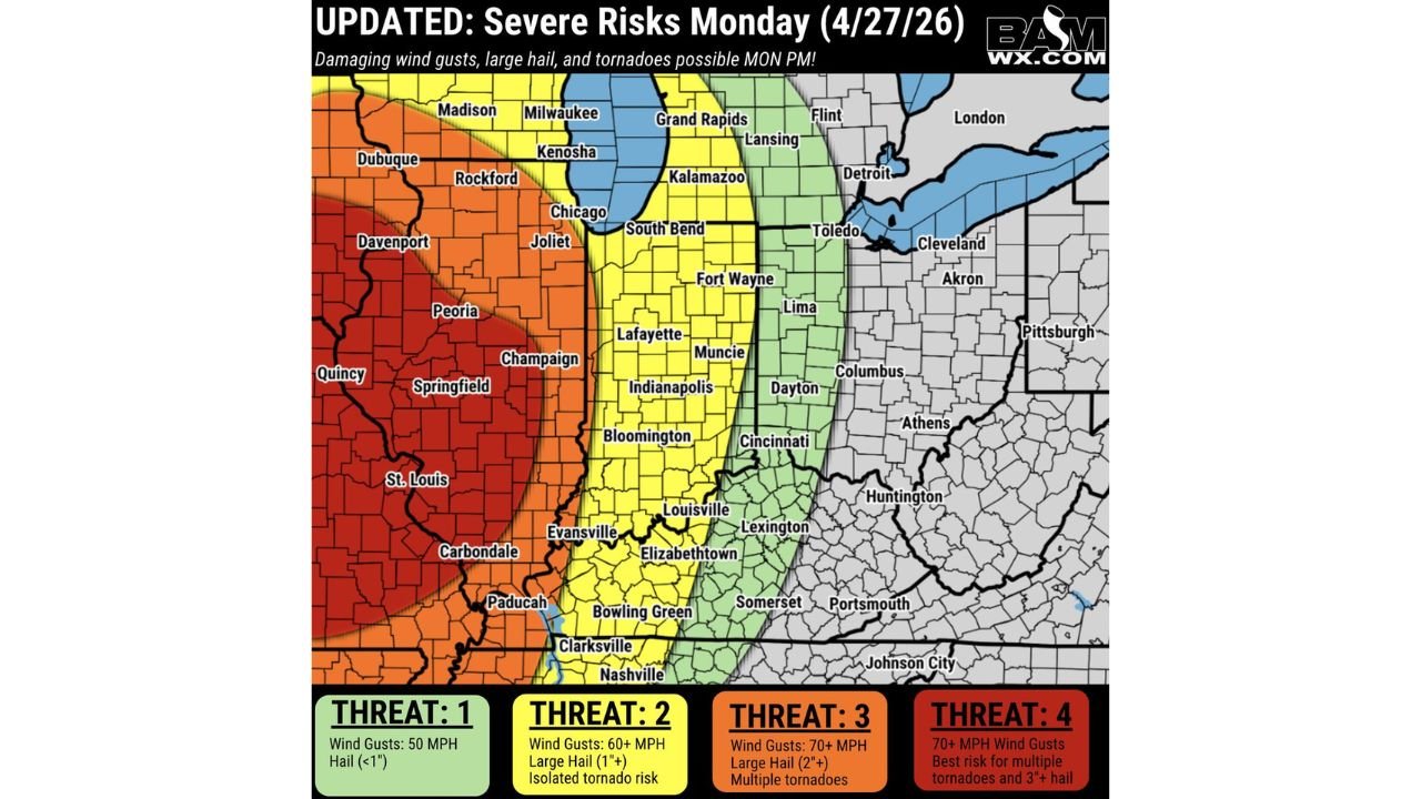
The updated severe risk map breaks the danger zone into four threat levels, each carrying a distinct set of hazards:
- Threat 1 (Green): Wind gusts up to 50 MPH, hail under 1 inch — areas like Detroit, Toledo, and parts of western Ohio
- Threat 2 (Yellow): Wind gusts 60+ MPH, large hail 1 inch or greater, isolated tornado risk — Indianapolis, South Bend, Louisville, Cincinnati, and surrounding areas
- Threat 3 (Orange): Wind gusts 70+ MPH, large hail 2 inches or greater, multiple tornadoes possible — Chicago, Joliet, Rockford, Evansville, Nashville corridor
- Threat 4 (Red): 70+ MPH wind gusts, best risk for multiple tornadoes and hail 3 inches or larger — Peoria, Springfield, Champaign, St. Louis, Quincy, Carbondale
Cities Most at Risk Monday Evening
The Threat 4 zone — the highest on the scale — covers some of the most densely populated areas of Illinois and Missouri. Key cities in the bullseye include:
- St. Louis, MO — directly in the Threat 4 corridor
- Springfield, IL — high risk for multiple tornadoes and significant hail
- Peoria and Champaign, IL — both under the most dangerous risk zone
- Chicago and Rockford, IL — Threat 3, damaging winds and tornadoes likely
- Indianapolis, IN — Threat 2, tornado risk cannot be ruled out
- Nashville and Clarksville, TN — southern edge of the Threat 2–3 zone
What Makes This Setup So Dangerous
Monday’s outbreak is particularly concerning because all severe weather modes will be active simultaneously. That means forecasters are not just tracking one type of threat — they are watching for tornadoes, destructive hail, and damaging straight-line winds all at the same time, across the same region. This kind of multi-hazard event is what meteorologists classify as a significant severe weather outbreak.
The window of greatest concern is Monday afternoon into the evening hours, when daytime heating maximizes instability and storm cells are most likely to become organized and long-tracked.
What You Need to Do Before Monday Evening
- Identify your nearest shelter location — interior room, lowest floor, away from windows
- Charge your phone and have a backup power bank ready
- Download a weather alert app or have a NOAA Weather Radio on hand
- Move vehicles under cover — hail of 3 inches will cause severe damage
- Avoid all unnecessary travel Monday evening if you are in a Threat 3 or Threat 4 zone
- Check on elderly neighbors and family members who may need help preparing
Do not wait for the storms to arrive to start preparing. By Monday afternoon, conditions will be rapidly evolving and your window to act safely will narrow quickly.
About This ReportThis severe weather analysis is based on the updated BAMWx threat map issued for Monday, April 27, 2026, and reflects forecast conditions as of Sunday, April 26, 2026. Severe weather situations evolve rapidly — always monitor the National Weather Service and your local emergency management agency for the latest warnings and updates. Stay weather aware and have a plan in place before storms arrive.
Published for informational purposes only. Threat levels and affected areas are subject to change as the forecast evolves. Always follow guidance from the National Weather Service and local emergency management authorities.
Leave a Reply