OKLAHOMA — A growing severe weather threat is expected to intensify across Oklahoma this Saturday evening, April 11, 2026, as storms push out of the Texas Panhandle and into western portions of the state. The National Weather Service Storm Prediction Center has issued a Severe Weather Outlook valid through 7 AM CDT Sunday, April 12, warning residents across a broad swath of Oklahoma to remain alert as conditions deteriorate through the overnight hours.
Storms Moving Out of the Texas Panhandle Into Western Oklahoma
The primary severe weather threat is tied to a storm complex moving out of the Texas Panhandle and pushing into western Oklahoma as the evening progresses. Large hail, damaging winds, and an isolated tornado will all be possible as these storms track into the region during the evening and overnight hours.
Forecasters note that the storms are expected to weaken as they push further east into central Oklahoma. However, residents in western communities including Elk City, Woodward, Altus, and Lawton should remain on high alert through the earlier evening hours when storm intensity is expected to be at its peak.
Slight Risk Zone Covers Oklahoma City and Surrounding Communities
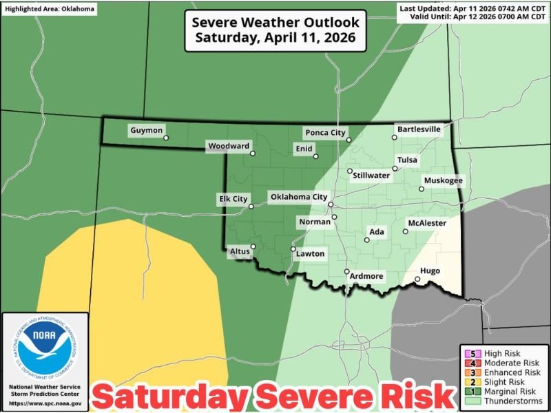
According to the NOAA Storm Prediction Center outlook map, a Slight Risk zone, rated level 2 out of 5, covers a significant portion of central and western Oklahoma. Communities falling within or near this risk area include Oklahoma City, Norman, Enid, Stillwater, Ponca City, Ada, Ardmore, and McAlester.
Residents across this corridor should have a way to receive weather alerts and be prepared to take shelter quickly if conditions deteriorate. While the Slight Risk classification indicates that widespread severe weather is not expected, it does mean that isolated severe storms capable of producing dangerous conditions are possible.
Scattered Storms Possible This Afternoon Ahead of Main Complex
Ahead of the main evening storm complex, scattered storms are expected to develop during the afternoon hours across parts of Oklahoma. The majority of this afternoon activity is not expected to reach severe thresholds, but forecasters caution that lightning and locally heavy rainfall are still possible.
These afternoon storms could impact outdoor activities across the region, and residents attending weekend events should monitor conditions closely. Even non-severe storms can produce dangerous lightning strikes and brief periods of heavy rain that reduce visibility and create slick road conditions.
Enhanced and Marginal Risk Areas Span From Guymon to Bartlesville
The NOAA outlook highlights varying levels of risk across the state, with an Enhanced Risk area, level 3, positioned along the western edge of Oklahoma near the Texas Panhandle boundary. A Marginal Risk, level 1, extends across a broader area covering communities from Guymon in the northwest to Bartlesville, Tulsa, and Muskogee in the northeast.
Residents across the Marginal Risk zone should not dismiss the threat entirely, as even lower-tier risk areas can experience isolated severe storms when atmospheric conditions are favorable. Staying informed through the National Weather Service and local broadcast meteorologists will be essential throughout the day and evening.
What Oklahoma Residents Should Do to Stay Safe Saturday
With storm conditions expected to intensify through the evening and continue into the overnight hours, Oklahoma residents are encouraged to finalize outdoor plans early and move inside well before dark. Charging mobile devices, downloading weather alert apps, and identifying the nearest sturdy shelter location are important steps to take before storms arrive.
Those in western Oklahoma, particularly in areas under the Enhanced and Slight Risk zones, should be prepared to act quickly if a tornado warning or severe thunderstorm warning is issued for their county. Conditions can change rapidly during evening storm events when visibility is reduced.
Are you tracking the storms in your area this weekend? Share your weather reports and stay informed at readcultured.com.
Leave a Reply