NORTH CENTRAL TEXAS — The first of two storm rounds is set to sweep through North Central Texas this Sunday morning, arriving from West Texas and pushing through the region between 6 AM and 10 AM. Forecasters are warning residents across the Dallas and Fort Worth metroplex and surrounding communities to expect gusty winds, frequent lightning, and pockets of heavy rainfall during the morning hours, though the activity is expected to remain below severe weather thresholds for most of the affected area.
Storm System Arriving From West Texas Early Sunday
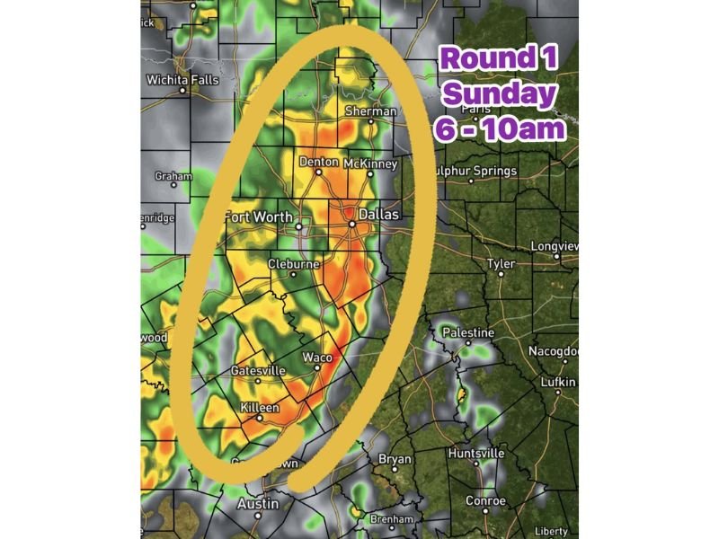
The Round 1 storm system is tracking eastward out of West Texas and is forecast to reach communities across North Central Texas during the early morning hours of Sunday. The primary window for this first round of activity runs from approximately 6 AM through 10 AM, giving residents a relatively defined timeframe to plan around before conditions improve.
Radar imagery shows the heaviest precipitation concentrated in a corridor running through Sherman, Denton, McKinney, Fort Worth, Dallas, Cleburne, Waco, Gatesville, and Killeen. Communities further east including Tyler, Palestine, and Sulphur Springs may see lighter activity along the fringe of the system as it pushes through.
Gusty Winds and Heavy Downpours Expected Across the Region
While Round 1 is not expected to reach severe weather classification for most areas, conditions will still be impactful for anyone outdoors or on the roads during the morning hours. Gusty winds, frequent lightning, and stronger wind gusts will accompany the heaviest cells as they track through North Central Texas.
Pockets of heavy rain and strong downpours are expected, particularly across the Fort Worth and Dallas corridor. Drivers should reduce speed and increase following distance during periods of heavy rainfall, as standing water on roadways can develop quickly even with non-severe storm activity.
What Comes After Round One
Residents should be aware that Sunday’s storm threat does not end with the morning system. A second and considerably more dangerous round of severe weather is forecast to develop across Central and South Texas during the afternoon and evening hours, with flash flooding, large hail, damaging winds, and an isolated tornado risk all possible south of Interstate 20.
Staying weather-aware throughout the entire day on Sunday will be critical for all residents across the region. Keeping a weather alert source readily available between the two rounds will ensure no one is caught off guard when the afternoon storm threat escalates significantly.
Are you tracking Sunday’s storm system in your area? Share your weather updates and stay safe at readcultured.com.
Leave a Reply