UNITED STATES — A dramatic temperature contrast is setting up across the country through mid-April, with cities including Dallas, Oklahoma City, Wichita, Chicago, Detroit, and Cleveland experiencing rapid warming trends, while colder anomalies persist farther north, creating a sharp divide in weather conditions.
Warm Air Expands From Southern Plains Into Midwest Cities
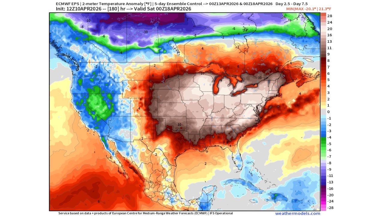
Forecast data shows a strong push of above-average temperatures spreading from the southern Plains into the Midwest, impacting major cities such as Dallas, Oklahoma City, Wichita, Kansas City, St. Louis, and Chicago.
These areas are expected to experience significant warming compared to seasonal norms, with daytime temperatures trending well above average for mid-April.
The warming pattern is driven by a large-scale atmospheric ridge, allowing warm air to surge northward and dominate much of the central United States.
As a result, residents across this region can expect:
- Comfortably warm afternoons transitioning toward early summer-like conditions
- Higher-than-normal overnight temperatures
- A noticeable shift away from early spring variability
Cold Anomalies Hold Across Northern Tier Including Great Lakes And Upper Midwest
While much of the central and southern U.S. warms, colder-than-normal conditions remain locked across northern areas, particularly near the Upper Midwest and Great Lakes region.
Cities such as Minneapolis, Green Bay, and parts of northern Michigan may continue to see below-average temperatures, creating a stark contrast with warmer regions just to the south.
This setup results in a tight temperature gradient, meaning:
- Sharp changes in temperature over relatively short distances
- Increased potential for active weather boundaries
- Continued variability across northern states
Even areas like Detroit and Cleveland, which sit closer to the transition zone, may experience fluctuating conditions depending on how far north the warm air can push.
Mid-April Pattern Signals Increasing Weather Volatility
This type of pattern, where warm and cold air masses collide, often leads to increased weather volatility, especially across the central and eastern United States.
The clash between these air masses can:
- Help fuel storm systems along the temperature boundary
- Create shifting weather conditions from day to day
- Lead to uncertain forecasts in transitional zones like Illinois, Indiana, and Ohio
Cities including Chicago, Indianapolis, and Columbus may find themselves near this boundary, experiencing both warm surges and occasional cooler intrusions.
Impacts Expected Across Major Cities From Plains To Great Lakes
From Dallas to Chicago and into Detroit and Cleveland, the evolving temperature pattern will bring a mix of impacts, including:
- Early-season warmth encouraging outdoor activity and seasonal changes
- Inconsistent temperature swings affecting daily planning
- Potential for storm development along temperature boundaries
This variability is typical of mid-April but is amplified this year due to the strength of the warm anomalies spreading northward.
What This Means For The Rest Of April
Looking ahead, the current setup suggests that above-average temperatures may dominate much of the central and eastern United States, while cooler pockets linger in northern regions.
For cities like Chicago, St. Louis, and Kansas City, this could mean:
- Continued warmer-than-normal conditions overall
- Occasional cool-downs tied to passing weather systems
- Increased chances for active weather patterns as systems move along temperature boundaries
Residents across the affected regions should be prepared for rapid changes in weather conditions, especially as the atmosphere remains dynamic through the remainder of the month.
For more updates on temperature trends, storm patterns, and regional weather impacts, visit Readcultured.com and stay informed as this shifting mid-April weather pattern continues to evolve.
Leave a Reply